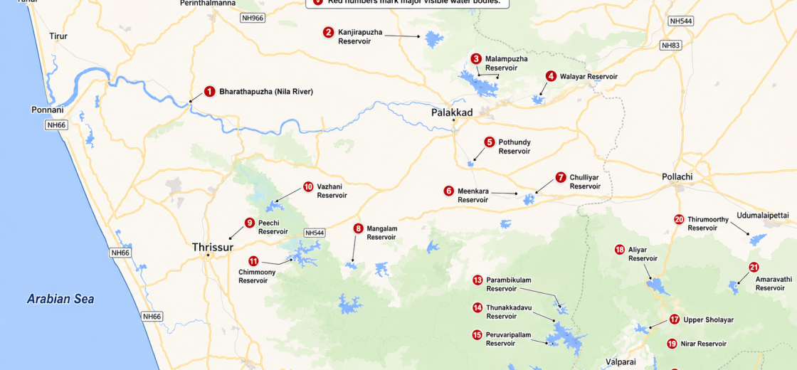

Major Dams, Reservoirs and Water Bodies Around Palakkad: Understanding the Region Through a Map
Look at a map of Palakkad and the surrounding Western Ghats and one feature immediately stands out: water.
From the sprawling Malampuzha Reservoir north of Palakkad to the Parambikulam-Aliyar system deep inside the Anamalai hills, the region is covered by rivers, reservoirs, diversion structures, canals and hydroelectric infrastructure.
These blue patches on a map are not isolated lakes.
Together, they form an extraordinary water-management landscape connecting Palakkad, Thrissur, Pollachi, Udumalpet, Valparai and the Western Ghats across Kerala and Tamil Nadu.
Some reservoirs primarily irrigate farmland. Others generate electricity. Some supply drinking water. Several perform more than one of these functions. A number of them are interconnected by tunnels and canals that move water from one river basin to another.
For Palakkad in particular, understanding these reservoirs also helps explain the district’s agriculture, settlement pattern, river systems and its long-running water-sharing relationship with Tamil Nadu.
Why Palakkad Has So Many Reservoirs
Palakkad occupies a geographically unusual location.
To its east lies the Palakkad Gap, the major natural opening through the otherwise continuous Western Ghats. To the south are the Nelliampathy and Anamalai ranges, which receive heavy monsoon rainfall. Numerous rivers originate in these mountains before flowing towards Kerala or Tamil Nadu.
The result is a region highly suitable for reservoir construction.
Palakkad’s irrigation network includes major schemes such as Malampuzha, Kanhirapuzha, Walayar, Pothundy, Mangalam, Meenkara and Chulliyar.
South-east of Palakkad lies an even more complex network: the Parambikulam-Aliyar Project, commonly known as PAP.
PAP is an interconnected system of reservoirs, tunnels, power houses and irrigation canals spread across Kerala and Tamil Nadu. It is one of the most striking examples of large-scale inter-basin water management in southern India.
1. Bharathapuzha – The River Connecting Much of the System
The Bharathapuzha, also widely known as Nila, is the dominant river system of central Kerala.
Several rivers and streams draining Palakkad ultimately become part of the Bharathapuzha basin.
Malampuzha, Kanhirapuzha, Gayathripuzha and Chitturpuzha are among the tributary systems connected to it.
On the map, Bharathapuzha can be seen flowing westward across the plains before eventually reaching the Arabian Sea near Ponnani.
The river is more than a physical watercourse. It has played a major role in Kerala’s agriculture, settlement patterns, literature and cultural history.
Major Reservoirs in Palakkad District
2. Malampuzha Reservoir
For most people in Palakkad, Malampuzha is the district’s most recognisable dam and reservoir.
The project consists of a dam across the Malampuzha River, a tributary of Bharathapuzha.
The reservoir supports a large canal irrigation system serving agricultural areas of Palakkad district. It also contributes to drinking-water supply for Palakkad town and neighbouring areas.
Its importance therefore goes far beyond tourism.
Primary roles: Irrigation, drinking water, flood management and recreation.
3. Kanhirapuzha Reservoir
Located towards Mannarkkad, Kanhirapuzha Reservoir forms another major part of Palakkad’s irrigation infrastructure.
The dam is built across the Kanhirapuzha River, which joins the Thuthapuzha and ultimately the Bharathapuzha system.
The surrounding hills and forested landscape also make Kanhirapuzha one of the more scenic reservoir areas in the district.
Primary role: Irrigation.
4. Walayar Reservoir
The Walayar Dam lies near the Kerala-Tamil Nadu border, east of Palakkad.
It is constructed across the Walayar River, which forms part of the broader Bharathapuzha drainage system.
Its location close to the Palakkad Gap makes it geographically interesting. The surrounding landscape transitions rapidly from the wetter Kerala side of the Ghats to the comparatively drier Coimbatore plains.
Primary roles: Irrigation and local water needs.
5. Pothundy Reservoir
Located near Nenmara at the foot of the Nelliampathy hills, Pothundy Reservoir is one of southern Palakkad’s important irrigation reservoirs.
The reservoir receives water from streams descending from the Nelliampathy hills.
Its canal network supports agricultural areas in the Chittur and Alathur regions.
Paddy is a major crop in the command area, although coconut, banana, arecanut, vegetables and other crops are also grown.
Primary role: Irrigation.
6. Meenkara Reservoir
Meenkara Dam is part of the Gayathri Irrigation Project.
The reservoir is built across the Meenkara River, a tributary within the Bharathapuzha basin.
Meenkara supports agriculture in southern Palakkad and also contributes to limited local water requirements.
Meenkara and Chulliyar are better understood as parts of the same broader irrigation system rather than as completely isolated reservoirs.
Primary roles: Irrigation and limited drinking-water supply.
7. Chulliyar Reservoir
The Chulliyar Dam is located in the Muthalamada region.
It forms another component of the Gayathri Irrigation Project.
A link canal allows water from Meenkara to be diverted towards Chulliyar under suitable conditions.
This is a useful example of why reservoirs should not always be viewed as independent blue patches on a map. They often operate as part of an engineered network.
Primary role: Irrigation.
8. Mangalam Reservoir
Mangalam Dam lies near Kizhakkenchery and forms part of another important irrigation scheme in Palakkad.
The dam is constructed across a tributary system that eventually joins the Gayathri River and then Bharathapuzha.
Its position below the Western Ghats allows it to collect runoff from a relatively compact but rain-rich catchment.
Primary role: Irrigation.
Reservoirs in the Thrissur Region
9. Peechi Reservoir
East of Thrissur lies Peechi Reservoir, one of the district’s most important water-storage systems.
The dam is built across the Manali River.
It plays an important role in irrigation and drinking-water supply around Thrissur.
The forested catchment surrounding Peechi also gives the reservoir ecological importance.
Primary roles: Irrigation and drinking-water supply.
10. Vazhani Reservoir
Vazhani Dam, near Wadakkanchery, is another important irrigation reservoir serving Thrissur district.
Its catchment lies along the lower slopes of the Western Ghats.
Compared with the giant reservoirs of the Anamalai region, Vazhani is relatively modest, but it remains important to local agriculture and water management.
Primary role: Irrigation.
11. Chimmony Reservoir
Further south-east lies Chimmony Reservoir, surrounded by the forests of the Western Ghats.
The landscape around the reservoir forms part of the ecologically important Chimmony Wildlife Sanctuary.
Its significance is therefore both agricultural and ecological.
Primary role: Irrigation, with major ecological importance in the surrounding catchment.
The Parambikulam-Aliyar Project: Where the Map Gets Really Interesting
The collection of reservoirs around Parambikulam, Valparai, Pollachi and Udumalpet is not accidental.
They form one of southern India’s most ambitious integrated water-management systems.
The Parambikulam-Aliyar Project transfers and regulates water through a combination of dams, reservoirs, tunnels, canals and power stations.
The system includes major components such as:
- Parambikulam Reservoir
- Thunakkadavu Reservoir
- Peruvaripallam Reservoir
- Aliyar Reservoir
- Nirar diversion system
- Tamil Nadu Sholayar Reservoir
- Connecting tunnels and canals
- Hydroelectric generation infrastructure
This is why a reservoir located physically inside Kerala may still form part of an infrastructure system whose water-management benefits extend deeply into Tamil Nadu.
12. Parambikulam Reservoir
The Parambikulam Reservoir is one of the largest and most significant storage structures in the entire PAP system.
It lies deep within the forested Parambikulam landscape of Kerala but functions as part of the interstate water-management network.
Water stored here can be transferred through tunnels and linked reservoirs before eventually being used for irrigation and power generation.
Primary roles: Water storage, irrigation transfer and hydropower support.
13. Thunakkadavu Reservoir
Thunakkadavu Reservoir acts mainly as a balancing reservoir in the PAP network.
Water from Parambikulam is conveyed towards Thunakkadavu through tunnel systems before continuing further through the interconnected infrastructure.
Primary role: Regulation and transfer of water within PAP.
14. Peruvaripallam Reservoir
Close to Thunakkadavu is the Peruvaripallam Reservoir.
It is another important storage and balancing component of the PAP system.
Primary role: Water storage and transfer.
15. Tamil Nadu Sholayar Reservoir
High in the Anamalai hills near Valparai lies Tamil Nadu Sholayar Reservoir, one of the most dramatic large reservoirs visible on maps of this region.
It forms an important hydropower and water-storage component of the wider PAP system.
Water diverted through the Nirar system contributes to the Sholayar network, where elevation differences are used for hydroelectric generation.
Primary roles: Hydroelectric power and water storage.
16. Kerala Sholayar and the Chalakudy System
There is another important Sholayar storage system on the Kerala side.
Water from Kerala Sholayar contributes to the Chalakudy River system.
Water released downstream reaches Poringalkuthu Reservoir, where hydropower generation also forms part of the river-management network.
This distinction between the Kerala and Tamil Nadu Sholayar systems is important because maps and casual descriptions often confuse the two.
17. Nirar Reservoir and Diversion System
The Nirar system, near Valparai, is another critical component of PAP.
Rather than simply storing water locally, Nirar helps transfer water between adjoining basins.
Its tunnel and diversion infrastructure illustrates the engineering philosophy behind PAP: use reservoirs, tunnels and elevation differences to move water across natural drainage boundaries.
Primary roles: Water diversion and hydropower support.
18. Aliyar Reservoir
Descending from Valparai towards Pollachi, one reaches the large Aliyar Reservoir.
Aliyar is one of the best-known PAP reservoirs on the Tamil Nadu side.
It supports irrigation and acts as an important regulating reservoir within the larger Parambikulam-Aliyar system.
Primary roles: Irrigation, water regulation and storage.
19. Thirumoorthy Reservoir
East of the Anamalai hills near Udumalpet lies Thirumoorthy Reservoir.
It forms an important downstream storage point within the irrigation network of western Tamil Nadu.
Much of the landscape east of the Ghats receives substantially lower rainfall than Kerala’s western slopes, making transferred and stored water especially valuable to agriculture.
Primary role: Irrigation storage.
20. Amaravathi Reservoir
Further east lies Amaravathi Reservoir, constructed across the Amaravathi River.
Although geographically visible on the same broad map, Amaravathi should not be confused with the core Parambikulam-Aliyar chain.
It belongs to a separate river and irrigation system.
Primary roles: Irrigation and river regulation.
Chitturpuzha: Where PAP Directly Matters to Palakkad Farmers
Perhaps the most important local connection between PAP and Palakkad is the Chitturpuzha Irrigation Project.
The Chitturpuzha originates in the Anamalai hills of Tamil Nadu.
On the Tamil Nadu side, the river is known as Aliyar. After entering Kerala it is known as Chitturpuzha.
Water distribution under this system is governed by the Kerala-Tamil Nadu Parambikulam-Aliyar arrangement.
The irrigation network serves large agricultural areas in Palakkad, Chittur and Alathur regions.
This explains why PAP water-sharing discussions are not some distant technical dispute.
They directly affect agriculture and livelihoods in Palakkad.
Not Every Blue Patch Is a Natural Lake
One of the most interesting lessons from this map is that relatively few of the large blue areas shown are natural lakes.
Most are man-made reservoirs.
A reservoir differs fundamentally from a natural lake because its water level, inflow and outflow are actively managed.
Engineers may release water depending on:
- Rainfall
- Irrigation demand
- Drinking-water requirements
- Hydroelectric generation
- Interstate water-sharing arrangements
- Reservoir safety
- Downstream river conditions
So the size of a blue patch seen on satellite imagery may vary dramatically between summer and monsoon seasons.
The Western Ghats Are the Real Water Tower
All these engineering projects ultimately depend on one natural system: the Western Ghats.
The Nelliampathy and Anamalai hills intercept moisture-laden monsoon winds arriving from the Arabian Sea.
Heavy rainfall on their western slopes feeds innumerable streams.
Reservoirs simply capture, store, regulate and redistribute part of this water.
This also explains the dramatic contrast visible on maps.
West of the mountains lies humid Kerala.
Immediately east of the Ghats, towards Pollachi and Udumalpet, rainfall drops sharply.
Water-transfer projects therefore move water not simply between administrative states, but between very different climatic zones.
A Remarkable Engineered Water Network
Seen individually, Malampuzha, Parambikulam, Aliyar, Pothundy and Sholayar are simply dams.
Seen together on a map, however, they tell a much bigger story.
They reveal a landscape where:
- Mountains collect water.
- Reservoirs store it.
- Tunnels move it through hills.
- Hydroelectric stations extract energy from it.
- Canals distribute it.
- Farmers depend on it.
- Cities drink it.
- Rivers eventually carry the remaining water towards the sea.
Very few maps explain Palakkad’s geography as clearly as a map of its water.
The district lies at a meeting point between the Bharathapuzha basin, Western Ghats, Palakkad Gap and Parambikulam-Aliyar water network.
Understanding these systems is therefore essential not only for understanding dams, but for understanding Palakkad itself.
Major Water Bodies on the Map at a Glance
| Water Body | Region | Main Importance |
|---|---|---|
| Bharathapuzha | Kerala | Major river system |
| Malampuzha | Palakkad | Irrigation and drinking water |
| Kanhirapuzha | Palakkad | Irrigation |
| Walayar | Palakkad | Irrigation |
| Pothundy | Palakkad | Irrigation |
| Meenkara | Palakkad | Irrigation and local water supply |
| Chulliyar | Palakkad | Irrigation |
| Mangalam | Palakkad | Irrigation |
| Peechi | Thrissur | Irrigation and drinking water |
| Vazhani | Thrissur | Irrigation |
| Chimmony | Thrissur | Irrigation |
| Parambikulam | Kerala / PAP | Storage and water transfer |
| Thunakkadavu | Kerala / PAP | Balancing and water transfer |
| Peruvaripallam | Kerala / PAP | Storage and water transfer |
| Tamil Nadu Sholayar | Valparai | Hydropower and storage |
| Kerala Sholayar | Kerala | Hydropower and Chalakudy river system |
| Nirar | Valparai / PAP | Water diversion |
| Aliyar | Pollachi | Irrigation and PAP storage |
| Thirumoorthy | Udumalpet | Irrigation |
| Amaravathi | Tiruppur region | Irrigation and river regulation |
A Note About the Map
The accompanying map should be treated as a regional visual guide rather than an engineering survey map.
Some smaller reservoirs and water bodies are not labelled, while reservoir surface area can change substantially depending on monsoon rainfall, seasonal releases and irrigation demand.
There are also multiple reservoirs carrying the Sholayar name in this broader region, so Kerala Sholayar and Tamil Nadu Sholayar should be distinguished carefully.
Conclusion
The water bodies surrounding Palakkad tell a story much larger than individual dams.
They reveal how geography, monsoon rainfall, agriculture, hydropower engineering and interstate water sharing are deeply interconnected.
From Bharathapuzha flowing towards Ponnani to the tunnels of the Parambikulam-Aliyar Project buried inside the Western Ghats, this entire landscape operates as one enormous water system.
For Palakkad, these reservoirs are not simply scenic landmarks.
They are part of the infrastructure that makes agriculture possible, supplies drinking water, supports electricity generation and shapes the economy of the region.
Understanding Palakkad means understanding its water.
